European Highpoints - Gross Glockner
By: Tom and Sigrid Sexton
Deciding what to climb for our 2003 trip to Europe didn’t take long; the Gross Glockner was unfinished business. Our two previous trips to Austria to climb the high point had been thwarted by bad weather. This year they were experiencing something akin to a drought. In looking at the route information, the Normal Routes go from the North Face and the South Face and both are rated as “II,35°“ the difference is in the number of crevasses. The North Face is listed with “many” and the South Face has “some”. The previous trips we had aimed for the ‘many’ over the ‘some’ because the north was more straightforward in terms of route finding. This year, the thought of going back to the same place to try the same route was too much, so we headed off to find Kals and the South side.
We got an early start from Lahr, Germany and sticking to the Autobahn for as long as possible, got to Kals in late afternoon. Kals is a small village bordering the Hohe Tauern National Park and, is situated in one of the most beautiful valleys I’ve ever had the pleasure to visit. It’s actually a collection of several villages catering mostly to the European ski trade in the winter, and hiking activities in the summer. There are several very nice hotels and numerous farms that offer rooms. The latter gets my vote for the opportunity to meet and mingle with some locals on a working farm.
Our first day involved about 1800m to the Adlerssruhe hut (3451 m) so we weren’t in too big a hurry to get started. After breakfast we were loading up the car and noticed a climbing shop with a “Sale” sign. OK, a little shopping and then we climb (I’m a gear junkie, what can I say). As you can imagine, the high point of Austria gets a lot of traffic so the hike was mostly on well-worn trail. If memory serves me, we parked at the Lucknerhaus and hiked past it and the Lucknerhütte (2241 m) to the Stüdl Hutte (2801 m). There were 2 trails heading up and we followed one that I later found leads to the start of the Stüdlgrat route (an absolutely beautiful ridge line!!). We reached the ridge, got our bearings and down climbed to the glacier (Kodnitzkees). We were eating lunch and roping up when we met 2 parties of Polish climbers. They were very friendly folks, but very lacking in basic mountaineering gear. By the time we finished roping up, we had picked up 4 strays on our rope. It wasn’t a big problem as there was a good line through the glacier and not much chance of falling through. At the eastern edge of the glacier we started up a ridge to the hut. There was some climbing involved on the ridge, but there were plenty of cables and such for protection.
Reaching the hut was a relief, as it was just starting to rain when we got to the door. This was the beginning of a very impressive storm. We were sleeping on the upper floor and the lightening, thunder, sleet, hail, and rain didn’t give me a whole lot of confidence for the following day. We would worry about that in the AM, for the evening there was beer to drink, dinner to eat, and much conversation to be enjoyed.
The following AM the storm had passed and after a second cup of coffee with the summit peeking in and out of the clouds we started up. The route climbs a snowfield to a gully that was a thin layer of snow over ice, reminding me of the climb up to the U-Notch. As in most popular Alpine routes this one was well protected with good bolts in the right hand wall. Three or 4 pitches of ice put us at a saddle and a third class climb to the top of the ridge.
The route markings led along the crest of the ridge, which climbs up to the Kleinglockner down to a notch and then up to the Grossglockner. We were just late enough on our start that we were getting some return traffic and the ridge looked kind of crowded. We took a look to the left, well below the ridge, and it seemed to go. So we set a belay and found a nice route that contoured around. There weren’t any markings, but it was clear that it was well traveled. On the other side we descended slightly to the notch between the 2 summits. From the notch the route went up a couple of pitches of low fifth and then to the summit. Again, this reminded me of the U-Notch only a good bit narrower, just big enough for a couple of parties. Just as we got to it, a party started down from the summit to the notch, so we tied off and waited.
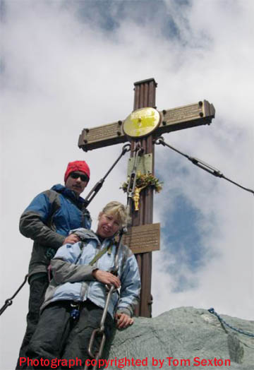
The party coming down was immediately followed by another and another and…! We waited about 30 minutes or more, getting pretty cold in the process. A guide, with client came up behind us, then past us, and started up the wall. I learned a quick lesson in Alpine climbing; if you hesitate you’re lost. The climbing was good, the bolts looked new and the holds were solid. From the top of the rock it was just a short stretch to the summit and the “Alpenclub Osterreich” cross at 3798m.After descending, we had a nice dinner and a very comfortable room at a farm before driving back to Germany
In the morning. We rested up for a few days, re-racked our gear and set off to tackle the high points of Belgium, the Botrange, at 2,276 ft. (694m) and of Luxembourg, Burgplatz 1,843 ft. (559m). No route information is needed here, but I’d be happy to help out with a road map.